I went off for a jaunt around Palos Verdes Peninsula again yesterday, on my own this time. I had a curiosity. I've ridden elements of the loop route separately, but I hadn't done the whole thing yet.

On this map (which is not exactly the route I took), I live over on the right side, about where the A in Angeles is. So I ride west, across the road labeled as 103, and intercept the route that's marked on this route, then I typically head south, instead of taking the road north as shown on this map.
Palos Verdes Peninsula is ringed by four roads: Palos Verdes Drive East, South, West, and North. Until yesterday, I'd never done the whole loop. I've gone up Palos Verdes Drive East to the top before, but the day I did that I didn't know the elevation profile for the rest of the ride, and I decided not to take the chance they all had wicked steep climbs like the one I'd just finished.
Since then, I've had the chance to ride the rest of the route, which has rolling rises and falls but is mostly quite pleasant.
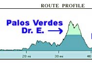
I stole the route profile above, by the way, from someone else's site. It would be nice to be able to generate elevation profiles like this myself. I hope someone at Google Earth is working on that right now.
I attack the route in the reverse direction from what's shown, so I go from right to left across the profile you see. The first peak (going from right to left) is about 800 feet in elevation; the second is still under 1,000--probably around 900? And the horizontal scale is very compressed, so it looks more daunting than it is.
But it's still a real grind to get up there. The sign I photographed before that said the road ahead was not suitable for bicycles was in Miraleste, which is on the map above; it sits in the valley between the two peaks. The shoulder's narrow, but other than that the road is fine.
After I ride Palos Verdes Drive East, which has the bulk of the hill climbing on this route, I head west, then north, then east again across Palos Verdes Drive North (not highlighted on the map above), until I come back to the start of the loop. Then I just head east again till I get home. Simple, no?
 As you come over the top of the hill, you see this view off to the west. The road follows the top of the bluffs. Yesterday a stiff wind was blowing from the west, which meant that even on the downhills I was fighting to keep going.
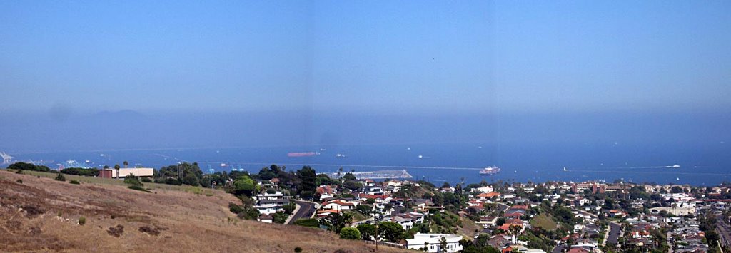
This is the view to the southeast. About a third of the way in from the right edge, you see a large container ship just entering L.A. harbor. You can see the breakwater that encloses the Port of Long Beach. (Click on the picture to see the enlarged version.)
 Here's the road down to the top of the bluffs. Nicely graded S curves. No cover from the sun for riders headed uphill on this road. I was on my way down.
 Further along, you get to Portuguese Bend, which is slipping gradually into the sea. There's not much the road engineers can do to keep the road smooth here, short of building a suspension bridge so the roadway wouldn't rest on constantly moving earth. It makes for entertaining riding and driving.
 Roadworks crews do all they can to keep the road drivable. Mostly that means putting down patches as quickly as cracks open up. Even so, the patches only last so long before the ground settles and slides again.
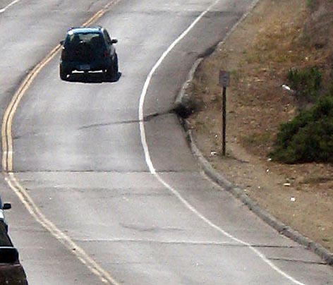 Here's a detail to show the level of bumpiness in the road. This is a major thoroughfare around the peninsula; anyone who has to get from one side to the other doesn't have a lot of choices.
I'm tossing this picture in to keep the record complete. It's from a ride I took last week. This is looking back down a hill I'd just climbed. I didn't think it looked that steep in the picture, but my brother was impressed. When you look at it, tilt the monitor back and see if it doesn't look steep. It was a stiff ride up, probably a 4% or 5% grade for 2.5 miles.
Last week's ride supposedly had 2,900 feet of climbing in it, which was a taste of what I expect to get next week at the Cool Breeze Century, with 3,500 feet of climbing. Last week's ride was 54 miles, the day after I'd gone 50+ miles on the (mostly) flat. From recent rides, I'm comfortable believing I'll make it through the century (100 miles), but I expect I'll be pretty drained by the end of it.
It seems easier, and it's definitely more fun, when you're sharing the road with other folks who are feeling similarly punished. But 3,500 feet is 3,500 feet, and the last time I rode the Cool Breeze, I remember a draining crosswind for the last several miles. I'll be glad to get to the pasta dinner by the end, when the spinning wheels can stop going round.
3 comments:
Do you still get the pasta if you don't finish?
Yow. That's a hell of a profile. Of course, without the vertical axis marked, that might be climb from one to five feet in elevation, but from the pics, that's obviously not the case. Nice ride.
Dude, look at the scale on the bottom. That's 30 miles, straight up.
Pasta, hmmm, pasta. Yeah, I think you can get it if you have the ticket that says you registered, but in order to get it you have to get back to the start line somehow . . .
Post a Comment