I wake up every morning and look out at the Palos Verdes Peninsula, which sticks up about 1500 feet above sea level (where I live). But when I go cycling, because the roads from here to Palos Verdes run pretty ratty, I usually ride south and east, along the beach, rather than west and north, toward the hills.
Lately it has come to my attention that my legs turn to spaghetti on real hills. Also, it crosses my mind that even on the flat I'll probably cycle better if I train in hills. (I grew up in Northern California, where real hills were easy to come by.)
So I got up this morning with the idea in mind of rectifying this unfortunate omission from my training schedule.
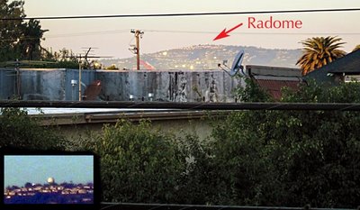
 Here's the target, as seen from my balcony. (Actually, I have a feeling what I'm calling the radome here is actually a big white water tank. Same general area on the hill, though. We specialists call that the "top.")
 You can see what I mean about ratty roads between my place and the hilltop. It's mostly industrial neighborhoods, with everything lying in the gutter that you can imagine falling off a truck. The bridge on the right, by the way, is the Vincent Thomas suspension bridge leading into San Pedro (in the foreground, out of the frame to the right). If you follow that road off into the distance, you'll find, if you look really closely, the Gerald Desmond Bridge, an arch-shaped steel bridge slightly to the right of the arrow tip. That's on the same highway, but it's much closer to my home. I was nearly arrested once for taking pictures from that bridge, but that's a story for another time.
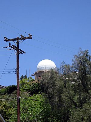
The radome, from a closer vantage.

When you get up to the top of the hill, you can look north and see the northern (west-facing) beaches of Los Angeles: Manhattan Beach, Redondo, Santa Monica, Venice, and so on. Below Palos Verdes are the beaches I normally ride, which mostly face south: Seal Beach, Sunset Beach, Huntington Beach, and on into Orange County.
The ride turned out to be a good trial run. I'm still figuring out the best route. Next time I might tweak it to get to a somewhat different destination, but this worked really well for today. About three hours after I left home, I was back unlocking the back gate again. Enough to get the heart unclogged without depleting me completely.
4 comments:
Nice pictures, both of this ride and of the river ride. I've been too busy putting together the dresser/changing table and cleaning out 3B's room to get around to the blog. But I'm sure that I will real soon now.
p.s. How rude of them to make you ride all that way, then call you dips. Whoever would do such a thing as that?
Boy is it smoggy where you live! Are you sure it's healthy to ride your bike so far while breathing that horrible air?
A.
Smog is orange (or brown). It's smoke + fog. What you're seeing here is mostly haze from the ocean. There are days when you can't see Catalina Island 26 miles offshore, and that's not because of all the cars driving between here and there.
I won't say there's no other particulate matter aloft: You're looking directly across one of the world's five busiest ports, which handles about 75% of Pacific Rim trade per year, as well as some decent-sized refineries.
But since this picture was taken on a Sunday, I'd guess more of the extra load in the air was from backyard barbecues than from burning bunker oil.
I remember the air down here in the 1970s, when the smog laid so thick some summer days you couldn't take a deep breath without feeling it in your lungs. And even today we're no Switzerland. But great strides have been taken, and you can see the mountains over L.A. much more regularly than you used to.
Besides, how creepy is it to breathe something you can't even see? Wouldn't you rather know exactly what's in the air you're using?
Your posts are making me almost miss LA. Or maybe the imaginary LA of my youth. I grew up in Westchester so the beach/industrial mix is somehow feeling normal to me. Scary.
Post a Comment